Thorold's Ancient Signpost
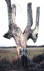
By Alun HughesBy the time the accompanying photograph was taken around 1980, the tree was a very forlorn sight. Once a stately elm rising over 25 metres, it was ravaged by Dutch Elm disease in 1970 and the following year, had its upper branches lopped off as a safety hazard. The stunted remnants survived another decade, losing additional limbs as rot set in, until the tree suffered the ultimate indignity of being blown down by a windstorm on the night of December 28, 1982.
That was the end of one of the most significant native relics in the area - Thorold's Indian Marker Tree, which had once served as a signpost on an ancient aboriginal trail. It was located just inside Thorold's boundary with Niagara Falls, about 30 metres north of the intersection of Townline and Old Thorold Stone Road.
Local historian, the late Fred Campbell poses in front of the ancient signpost. (Photo from the Fred Campbell Collection)
In its prime, it possessed a very distinctive shape, with two major limbs extending downward from the trunk and then suddenly rising vertically. At one time, trees of this kind were not uncommon in the Niagara Peninsula, marking significant locations (bends, intersections) in the trail network that criss-crossed the area, but all have now succumbed to the ravages of time.
In an earlier article in the Thorold News, the late Francis Petrie, former official historian for Niagara Falls, describes how the trees were fashioned.
"The bends were accomplished by bending the tree sharply, nearly half breaking it, and then tying it with green vines or rawhide strips until the deformation was permanent. Some such bends were often smeared with a crude form of pitch or resin to aid in holding their new shape. Another practice was to take a long branch, and bury it a few inches below ground level with the elbow sticking partly up and leaving it there until permanently deformed, then removing the branch from the ground. Of course, this necessitated the use of a fair-sized stone to keep the buried portion of the branch from breaking loose. A young, and quite pliable tree had to be the type used for bending and elm trees were ideally suited for this purpose…"
Before the opening of the Thorold Tunnel in 1968, when Old Thorold Stone Road was the main route to Niagara Falls, the marker tree was a familiar sight to the people of Thorold. Visitors to the spot today will find no sign of its presence, nor of the Indian trail that once ran alongside. Actually there may have been more than one trail - native oral tradition suggests that the location served as a trading site for a wide area-including the Mohawk Trail, a major east-west route through the Peninsula in pre-European times.
The most important route in the Peninsula was the Iroquois Trail, which ran from Queenston to Ancaster along the line of an ancient lake shoreline now followed by Highway 81. The Mohawk Trail was an offshoot of this. It left the Iroquois Trail at St. David's, climbed the Escarpment and followed the line of Mountain Road, turning south-west past the marker tree and linking up with what is now Beaverdams Road west of the canal.
It continued along the line of DeCew Road, and then followed the Escarpment edge westward to connect with the Iroquois Trail again at Ancaster.
These routes (and the marker trees along them) were naturally used by the early white settlers, and it is no coincidence that so many modern roads follow the ancient trails. Another example is Beaverdams Road in Niagara Falls, which before the building of the Fourth Canal used to connect with Marlatts Road in Beaverdams.
Though the marker trees that guided the native peoples through the Peninsula are no more, it's worth noting that a hefty limb of the Thorold Marker Tree was preserved and can still be seen in the Thorold Historical Museum.